


Do You Have A Surveying or Engineering Project? Let our Services Help!
Land Surveying Services
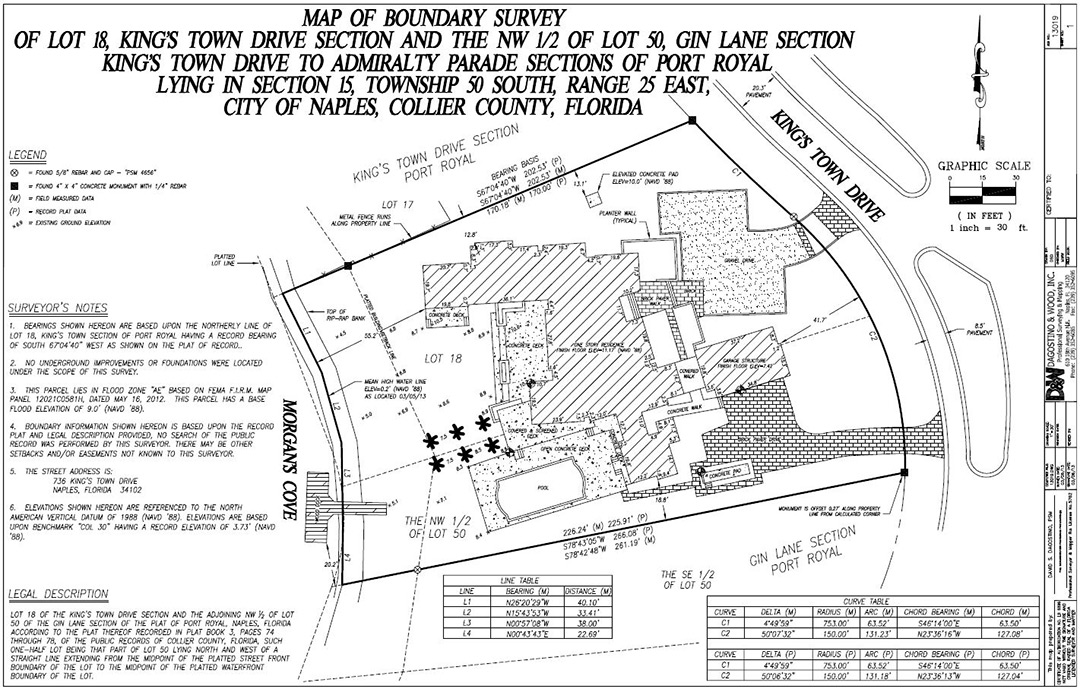
Boundary Survey
Target Surveying provides fast high-quality Boundary Surveys for the entire State of Florida, at the most competitive prices in the industry.
A boundary survey determines the property lines of a parcel of land described in a deed. It will also indicate the extent of any easements or encroachments and may show the limitations imposed on the property by state or local regulations.
A boundary survey is strongly recommended before buying, subdividing, or building/improving on land. Surveying the parcel before these activities ensure that the expense and frustration of defending a lawsuit, moving a building, or resolving a boundary dispute can be avoided.
Topographical/Architectural Survey
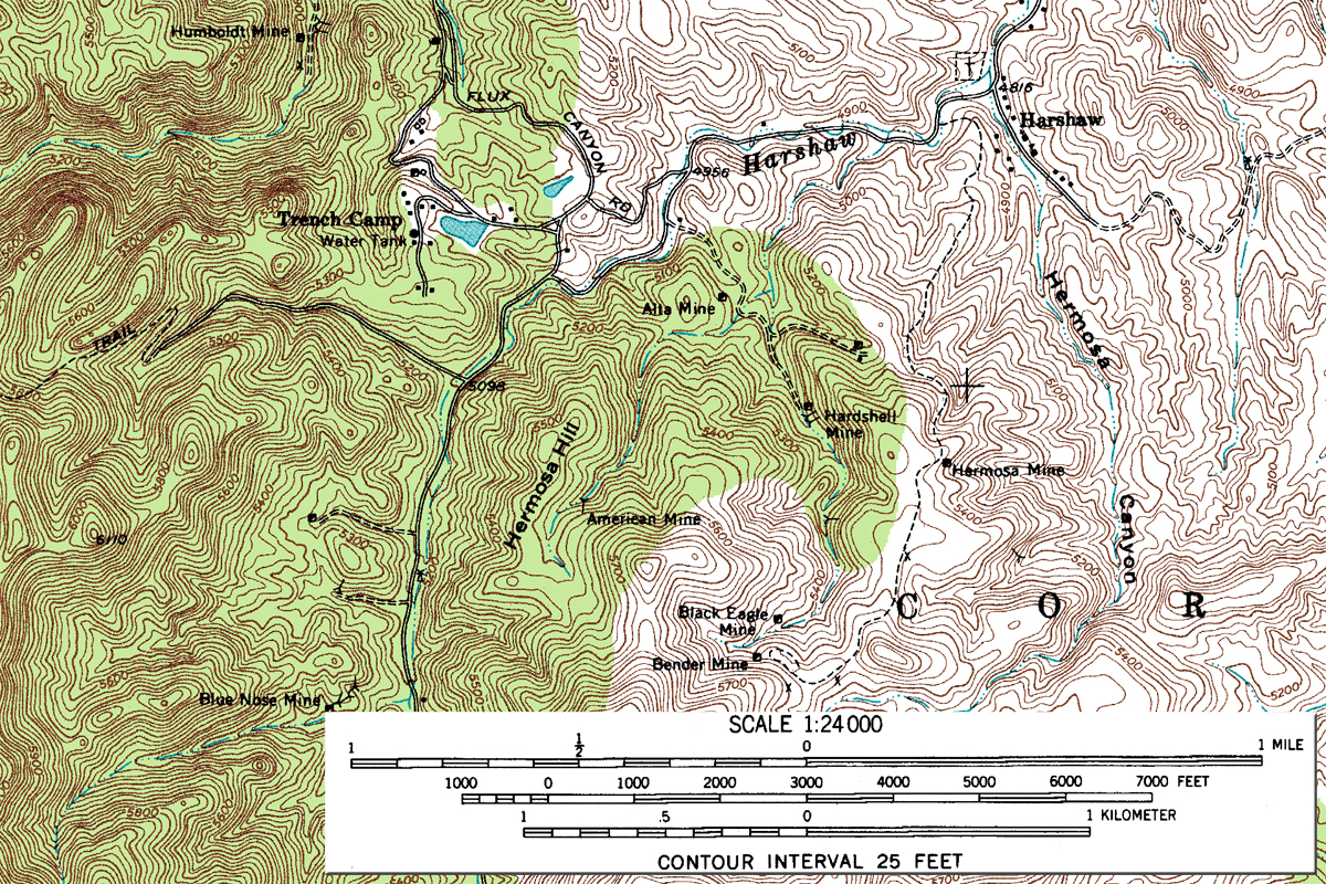
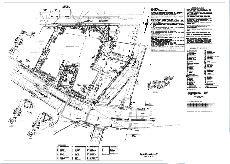
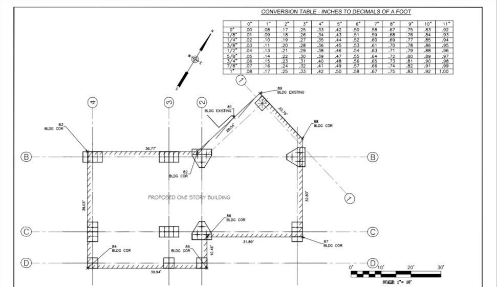
A topographic survey is very similar to that of a boundary survey and is usually essential for design purposes. Topographic surveys include elevations of the terrain to identify and map the contours of the ground either on the surface or slightly above or below the earth.
Topographic/Architectural Survey
Topographic surveys are one of the most detailed surveys, as it provides a plethora of useful information about the premises. It includes the location of the following natural and man-made features such as:
- Buildings
- Improvements
- Fences
- Elevations
- Land contours
- Outcrops
- Trees
- Streams, etc.
This type of survey may be required by a government agency or may be used by Engineers and/or Architects for the purpose of design for improvements/developments on a site.
- Sewers and Storm lines are located and depths are physically measured by our survey crews.
- Other surface utilities (i.e. valves, manholes)
Sidewalk entities located include:
- Pedestrian ramps
- Utility poles
- Mailboxes
- Street signs
- Curb cuts
- Water meters
- Light Poles
- Hydrants
- Catch Basins
- Overhead utility lines, etc.
Spot Elevations are taken inside the property and in the adjacent street at 25-foot or 50-foot intervals depending on property size. Major/Minor contour lines also used where applicable.
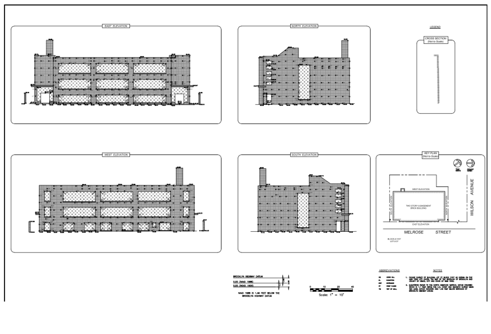
Façade Survey
A typical façade survey would consist of surveying the front, sides and back of a building and recording important structural details such as building lines, window openings, door openings, columns, trim detail, chimneys, etc. This information can highlight structural elements that would not be clearly visible from a floor plan.
By using our 3D Laser Scanner, we can easily measure the façade of a building with both accuracy and speed and enabling us to access areas that would otherwise be inaccessible.
SUBDIVISION/MERGERS/LOT LINE ADJUSTMENTS
Subdivisioning is the process of creating a new parcel of land out of a parent tract. Lot merging is the process of combining parcels of land into a larger tract of land. Lot line adjustments are any changes in the legal boundary between adjoining parcels of land.
The new lot lines are delineated by metes-and-bounds and are an important part of planning for development of the parcel. These are usually required if you are planning to:
- Building a second building on land that you own by subdividing
- Build a larger building by merging adjoining land
- Develop a community from a larger parent tract by dividing the land into the
- Adjusting a Lot line with your adjoining neighbor by way of a boundary line agreement
SURVEY REPORTS:
PROPERTY LINE STAKEOUTS
Property line stakeouts are done in order to place physical Mark at or near your property corners. This is typically done when your original Corner markers have been lost or there is uncertainty in a boundary line. Before any marking is done preliminary survey work is done and the data is analyzed in the office in order to retrace the boundaries using calculations and physical evidence documented in the field. Marking your property Corners can help you protect your investment in your property. These marks can then be used to build things such as fences and make sure that you do not encroach upon adjoining properties.
LEGAL DESCRIPTION
Legal Descriptions, or more commonly known as Deeds, are needed to convey the metes and bounds of a property in a verbal format. A recorded deed serves as a physical token to your title in a given property. The importance of having an accurate legal description for these purposes is invaluable. Only a licensed land surveyor is qualified to prepare a metes-and-bounds suitable for proper conveyance and description of land.
ALTA Survey
“ALTA” stands for American Land Title Association. All ALTA Surveys most meet the ALTA specifications and requirements.
The data required includes boundary lines, location of the main building including improvements, location of ancillary buildings, the identification of easements (access rights by service companies such as water, gas, telephone, railways and other utilities).
Target Surveying provides ALTA Surveys that meet all of the standards outlined by the American Land Title Association. We provide thorough accurate surveys, with a fast turnaround time at the most competitive prices in the industry.
Often considered to be the “Cadillac” of surveys. An ALTA survey is one that is done in accordance with the Minimum Standard Detail Requirements set forth by the American Land Title Association (ALTA) and the National Society of Professional Surveyors (NSPS). The ALTA is special because of the unique way that it addresses title insurance matters through utilization of the Surveyor’s Certificate.
ALTA specifies the data to be shown on the survey and this includes:
- Boundary lines
- Location of the main building including improvements
- Location of ancillary buildings
- The identification of easements (access rights by service companies such as water, gas, telephone, railways and other utilities)
Stakeout/Layout for New Construction
In a Stakeout survey, physical marks are set to guide construction.
- A Stakeout for new construction or extension shows builders where to dig.
- Physical marks are placed on the property showing builders where the footprint of the building is located.
- A drawing of the marks and their relation to the building is also provided.
- Benchmarks are also placed on-site in relation to the finished first-floor elevation of the proposed building(s) approved plans are required from the architect.
A follow-up to this survey is highly recommended, whereby the actual building corners are marked on the footing. As well as foundation checks to make sure the foundation is in the right place.
Foundation Surveys
are designed to locate improvements on a property concerning the property boundary & are often required for new construction.
Foundation surveys show the location of the foundation relative to the property lines & focus solely on the foundation of the structure, providing an effective “snapshot” of the foundation as of a specific date.
Elevation readings may also be taken throughout the foundation to identify any high or low points, serving as a baseline measurement.
In many cases, a foundation staking is done before the foundation survey.
The surveyor will take measurements, compare the measurements of the property to those of structure foundation, and make notes about size and location recorded in the property description on the deed.
Elevation Certificates
A Flood Elevation Certificate is a document prepared by an Engineer, Surveyor, or qualified person that will provide data to help properly rate properties for flood insurance. An Elevation Certificate can determine where, precisely, your home is located in relationship to the Base Flood Elevation. You may want to obtain a flood certificate if your property lies in a flood zone.
The Flood Disaster Protection Act of 1973 requires flood insurance to be purchased for properties in Special Flood Hazard Areas prior to the owners receiving any type of direct or indirect federal financial assistance. The flood certificate is a tool that FEMA (Federal Emergency Management Agency) to certify building elevations if the building is in a special flood hazard area. This form helps in determining the proper flood insurance rate for the building. Flood insurance may be required for residential and commercial properties.
Target Surveying provides fast accurate Elevation Certificates at the most competitive prices in the entire industry. Call us today to schedule your Elevation Certificate survey.
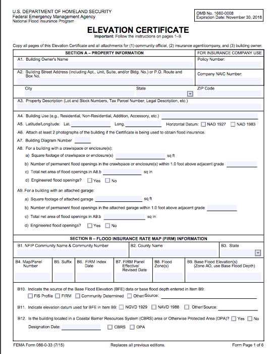
Elevation Certificates
An elevation certificate is a form created by FEMA for the purpose of determining if a structure on a given property is compliant with flood hazard area building code or for determining if it is within an SFHA or Special Flood Hazard Area.
It is a form that is filled out by a surveyor that certifies the elevations of the structure and the elevations of the land adjacent to a structure.
This is then used a few different ways.
The most common reasons are:
- To fulfill an insurance broker’s request for one.
- Used to support a Letter of Map Amendment (LOMA) or Letter of Map Revision (LOMR).
- Another reason is that a Bank may require for mortgages.

“Engineers don’t cry. They build bridges and get over it.”
LS Tech Land Surveying & Engineering, PLLC

Engineering Services
Structural Engineering Design
Our staff is experienced with technical and engineering expertise to approach any project. LS Tech PLLC has designed a wide range of structures, facilities, and buildings for both public and private sector clients. We are devoted to delivering innovative resolutions to all of our client’s projects including
• Correctional Facilities
• Police 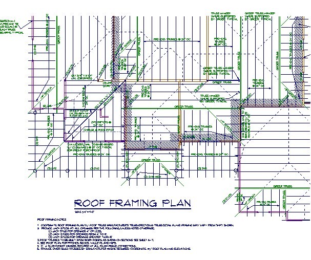
• Firehouses
• Courthouses
• Government Office Buildings
• United States Postal Services
• Cultural Facilities/Museums
• Educational Facilities
• Environmental Sites
• Hospitals
• Housing Complexes
• Parks & Recreational Facilities
• Religious Facilities
• Bridges
• Airports
• Tunnels
• Highways
• Retaining Walls
• Foundation Systems
• Culverts
Civil Engineering
We ware in the job of providing engineering services to improve our communities infrastructure. Many of our projects involve a broad range of Civil Engineering services including:
• Earthwork
• Excavation
• Drainage Systems 
• Site Grading
• Filling
• Site Geometry
• Curbing
• Paving
• Hydraulics
• Sidewalks
• Utility Connections
• Sanitary Sewers
• Stormwater Management
• Street Reconstruction
• Parking Lots
The review of design documents will be conducted and incorporated into specifications and cost estimates indicating layouts, profiles, sectors, details and related notes necessary to produce a highly reliable set of contract documents required for construction.
Architectural engineers apply science and technology to the real world by designing buildings that enhance our standard of living and improve our quality of life. They do this by combining building systems – structural, electrical, mechanical, lighting, acoustics and fire protection – into an integrated whole. These creative problem solvers are constantly facing the challenges of the future like sustainable building materials and green energy sources.

Bridge Engineering/Inspection
Our services range from Bridge Inspections to Bridge Engineering Design, our personnel are fully committed to providing high-quality work and are ready for any challenge. The bridge foundation projects are ready for the stability of the high elevated bridges. Our staff provides engineering inspection after storming events on an as-needed basis to the bridge owner. Our goal is to meet our and deliver a successful project design.